
So, afterward, the rest of my drive through the mountains of CO was pretty subdued. I didn't even take many more photos, aside from a couple of Dillon Pinnacle.
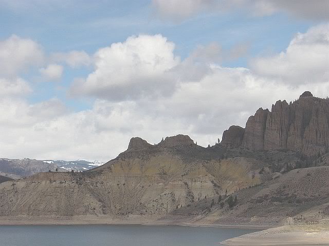
(Click here for more photos from Curecanti Creek and Dillon Pinnacle on Day 8.)
This was also the first day of the trip that I haven't crossed a state line. I pooped out here in Fruita, which is a funky little mountain bike- and dinosaur fossil-oriented town next to the Colorado National Monument, just a handful miles west of the Utah border.

Heck with yuppified, overpriced-gas Gunnison, I think I'd rather live here in Fruita. I've been sitting in the window of the coffee shop, looking at the sculptures along the sidewalks and at the wall murals, and noticing that the younger generation takes their coffee inside with newspapers and laptops, while the old-timers carry their cups outside for conversation on the street corner. Even the old dudes are wearing hiking boots.
But yet again, my dreams were smashed. Took a quick cruise through the residential district of Fruita. Similar to Gunnison, with little bungalows and single-level ranch-styles. And then... at the edge of town were not one but two brand spanking new, totally tree-less subdivisions. The devil developers strike again.
Just over the border into Utah, passed a big yellow road sign warning "Eagles In Highway". Sure enough, within a few miles I drove past one perched on the guardrail.
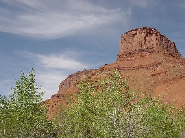
Today is my first pre-planned extended detour, to Moab, UT, home of slickrock bike riding and Edward Abbey. To begin, let me say that anyone passing through southeast Utah absolutely must drive the scenic byway of Route 128. A mile or two from the exit off of Highway 70/Route 50, is a sign that reads: "Beyond this point motor vehicle traffic is limited to paved roads and trails". This road is awesome Pony land and yes, I mean Ford Mustang, not horse. Two lanes very gradually descending westward through open range land, full of hills, dips and curves, with red rock mesas along the horizon. The Pony took it a bit above the posted speed limit, while I hovered my foot above the brake as we climbed each hill, for fear of finding a bovine roadblock just over the top. After a few miles of this, the road entered a gorge along the class II-III Colorado River. Through this stretch the scenery kept me at the speed limit as much as the hairpin turns did. I swear I bumped my lower jaw on the steering wheel a few times from gaping at the view.
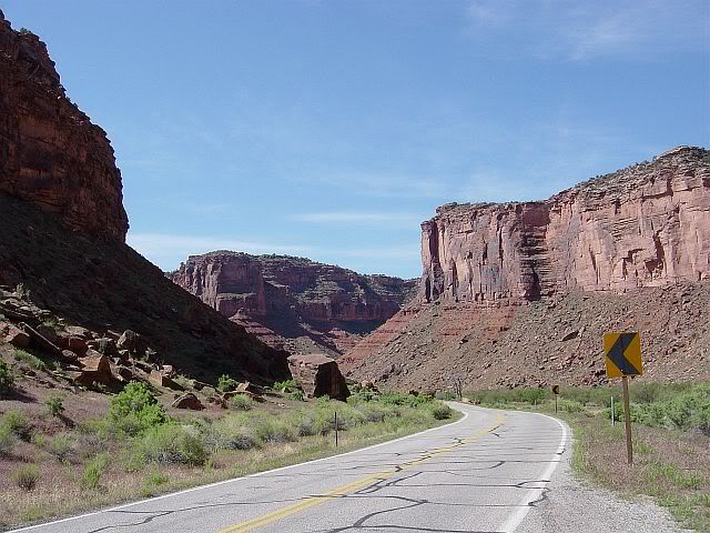
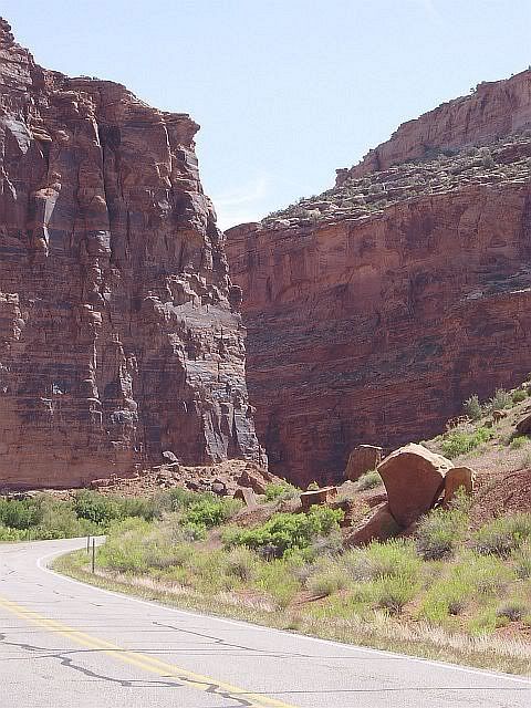
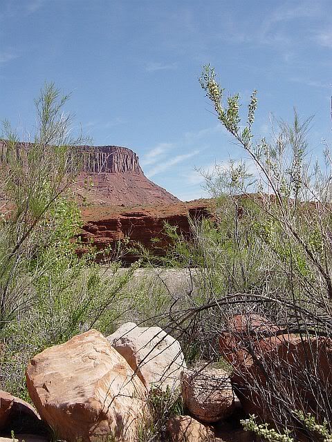
(For these and more photos of Utah, click here.)
43 miles later, Route 128 comes out at Moab, where I had lunch at the Peace Tree Juice Cafe (great recommendation from Susan at the Back of Beyond bookstore). Moab is pretty cool, as long as you can see past the yuppie-pandering river/mountain bike outfitters and overpriced gift shops. Gas is back up to $2.36 a gallon, so that tells you a lot about Moab. I'd give anything to have been able to see it in Abbey's time, though, when the tiny bars of Moab were filled with cowboys and miners rather than spandex clad yuppies. Or even better, to have seen it before then, when there was no town, no bars, and no outfitters, just indigenous peoples who felt no ownership over the land. While I appreciate many of the conveniences of progress and development, I'm seriously brought to tears sometimes thinking of what's been destroyed in gaining those conveniences, and infuriated by people who can't even begin to imagine the world without them. If you're so inclined, here are Abbey's thoughts on the issue. The man expressed it better than I could ever hope to.
I had planned to do the tourist thing at Arches National Park, but there were so many other tourists already there that I let them all do it for me. Instead I hit the highway or, more accurately, the interstate. Back near the Colorado border, 50 merges with Interstate 70 and stays that way more than halfway across Utah.
And, I find I misjudged Moab's gas prices. Apparently, any station in UT anywhere near a highway runs from $2.36 to up as high as $2.45. I guess the fact that people have to drive as far as 110 miles between stations gives the station owners license to jack up those prices.
At least there are plenty of restrooms, though. Scattered along 70/50 are numerous "view areas", pulloffs at particularly scenic spots with one or two interpretive signs about the area and a teeny restroom with pit toilets. I had to wonder if someone really had the forethought to plan those view areas into the highway design, or whether there were more than a few traffic accidents caused by people trying to pull off the shoulder of the highway to gawk. Which is worse: to slam on the brakes to pull over for a photo, or to hold the camera up with one hand and snap a shot while speeding along at 70 mph? Hmmmmmm...
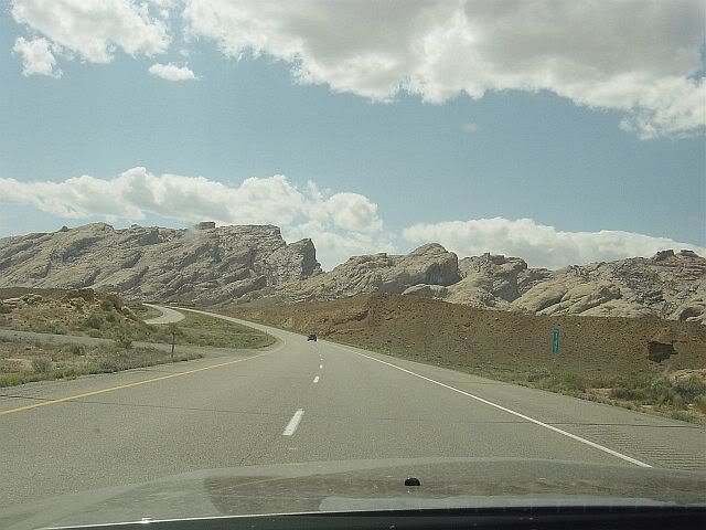
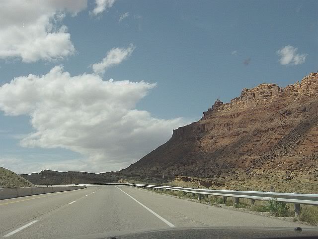
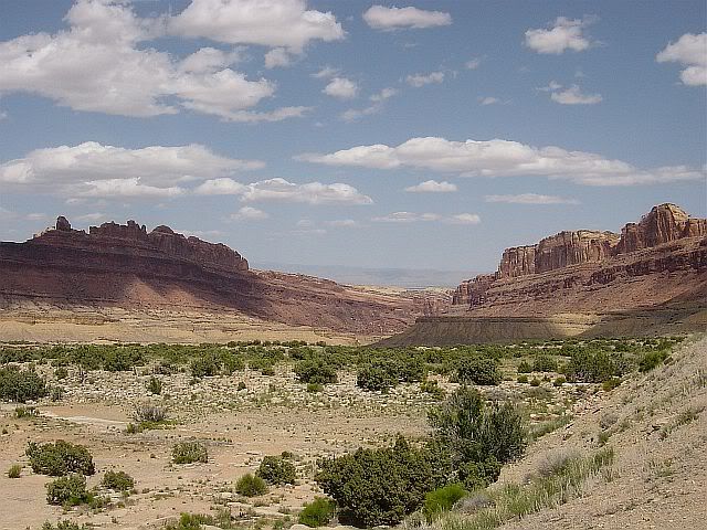
The landscape certainly is tremendous, too. There's such variety in the rock formations and colorations as the road passes through different areas that I wish I had picked up a geology guide at the bookstore in Moab. I have to admit, though, that I began to feel a bit uncomfortable at the lack of trees. Looking at all that rock and nothing above it but sky made me feel that spending a prolonged time in the area could fry your brain and make you crazy. As the interstate neared Salina and entered the Fishlake National Forest, the sight of pine trees climbing the mesas was a relief.
At Salina, 50 splits from 70 and takes a jagged course north, then south, then north again before heading west to Delta. By doing this, it manages to slip through a pass in a snow and pine covered mountain range, instead of climbing up and over like it did at Monarch Pass in CO. As spectacular as eastern UT is, I really enjoyed this stretch through Fishlake. It felt good to be back on two lanes. There's just something more intimate about two lanes and a single dividing line. It's almost as if you're in the scenery, as opposed to barreling through it (even if the speed limit on those two lanes is a breezy 65 mph).
Coming out of the Fishlake forest area was interesting. It was almost like being in Kansas again, except that instead of prairie was sand and those prolific sagebrush bushes. I swear, though, that the horizon was even farther away than in Kansas. Either that or there's just more sky in Utah. Whichever it is, it felt as if I could literally see for 30 miles across the total flatness, with utility poles and road heading off in the distance until they were microscopic. Delta, where I ended up at Best Western for the night, is 88 miles from the Nevada border but I have a feeling I've been given a preview of what to expect when I cross the state line. And speaking of expectations, a traveler through central Utah can't expect much in the way of accommodations. Delta's so tiny that Best Western is the only chain motel and I had to make do with McDonald's for dinner. Tomorrow will be even more stringent-- the 88 miles to the Nevada border looks on the map to be a stretch without a single town.
Wal-Mart count as of Delta, UT= The same as yesterday! I've seen not one Wal-Mart in Utah, though I did pass a few of their trucks.
Today's distance= 329 miles, including the 75 miles down to Moab and back up.


No comments:
Post a Comment